Wayfinding
Wayfinding has a profound impact on the user experience. In the university setting, students, families, and new faculty are navigating not just a new place but a space many of them will come to call home. With the cognitive load that comes with moving away from home for the first time or starting a new job in an unfamiliar place, navigating a new environment is inherently stressful. Good wayfinding lowers that stress. Finding your way around campus should be intuitive and easy.
Challenge
In recent years, Fort Lewis College has undergone an entire rebrand, built and renovated buildings, and relocated offices and departments across campus. The net result was sorely outdated wayfinding, incorrect signage, and maps that were more confusing than helpful. It was not going to be an easy fix. We had a backlog of hundreds of signs, names on buildings, and a digital footprint as well. And since the last wayfinding overhaul happened in the early 1990s, the college did not have a system in place to manage and track wayfinding updates and inventory. Finally, in the age of phones and Google maps, there was also a disconnect between the three stages of navigation: getting to campus and finding parking, navigating to the right building, and finding the particular room you are looking for.
Solution
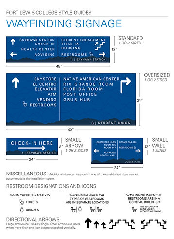
I established a new wayfinding branding guide and developed a system to track every building, every sign, and every location across campus. I also created a standardized convention for room numbering across campus. I then started with the most heavily trafficked building on campus--the Student Union--and updated wayfinding across campus. The work allows managers of each building on campus to locate and request replacements for building-specific signage in order to ensure that the campus wayfinding is kept up-to-date but also within brand.
Finally, I worked with the city of Durango to enhance the college's visibility. I rebuilt welcome signs at the city limits on the major highways into town and built out a specialized map on the city's digital mapping system, Wander Maps, to help people find their way to campus, find parking, and navigate digitally to their locations. This interactive map, in particular, has proven to be an effective tool for connecting all three stages of navigation and improving the overall experience.